a hot rock mantis production
your guide to Réunion Island
Ile de la Réunion
The original and most informative
English language guide to the island
Geography
a lively hotspot
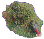
Located in the South-west of the Indian Ocean lthe island is elliptic in form, its greatest diameter measures 43 miles (70) km with a surface area of 1555 miles (2512 km²). The island is 39 miles (63 kilometers) long, is 28 miles (45 kilometers) wide. Reunion lies at 21°06' South and 55°32' East, which locates it to the North of the tropic of Capricorn. It is 700 km from Madagscar to the West and 180 km from Mauritius to the North-east.. In the context of the Western Indian Ocean, the submarine plateau of the Mascareignes constitutes the area North to the Seychelles with Mauritius, delimiting the trench of the Mascareignes to the West (-4000 to -5000 m), and that of Madagascar/Maurice in the South (-4000 with -5000m) and to Rodrigues in the East (-5000 m). On Réunion, the coral reefs are very localised covering part of the Western littoral. The lack of a continental shelf means that the sea quickly becomes deep not far from the coast.
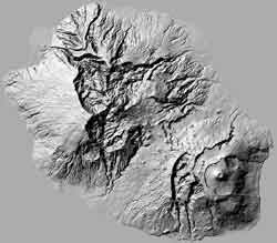
Reunion island is the result of volcanic activity which begun around five million years ago. Lava erupted from a hot spot in the oceanic crust to form a huge cone rather like a worm cast. It is thought that the "island" eventually emerged from the sea around three million years ago and gradually, with succesive eruptions and much erosion became the island that is still evolving today.. Two million years later, the first volcanic mass, the Piton des Neiges, was created. Deep under the ocean the "volcano" forms an immense cone with a base of 200km and a total height of about 7000m. The island, being located above a hot-spot in the Earth's crust, is slowly, and impercetibly, moving. It is made up of two distinct volcanoes - the Piton des Neiges (Snow Peak) which is now extinct and the younger and more active Piton de la Fournaise (Furnace Peak)
Piton de la Fournaise
young and petulant
The "Piton de la Fournaise" is a shield volcano on the eastern end of Réunion Island, and rises more than 8565 feet (2611 meters) above sea level and has erupted more than 100 times since 1640 and is under constant monitoring. It most recently erupted in April, 2007. See the volcano page for more infromation. It is one of the most active volcanoes on Earth and is one of the more passive, basalt or shield volcanoes.
Piton de la Neiges
old and wise
The "Piton des Neiges" is the highest point on the island and in the Indian Ocean at 10069 feet (3072 meters) above sea level, is west of "Piton de la Fournaise" volcano. Collapsed calderas and canyons are southwest of the mountain forming three cirques, which are similar to corries or calderas: the cirque of Salazie, the cirque of Cilaos and the cirque of Mafate. The latter is accessible only by foot or helicopter.
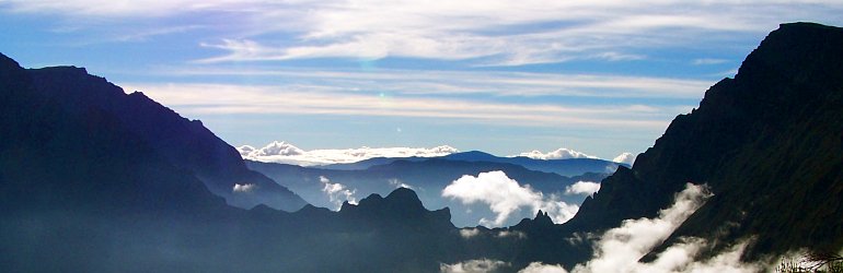
The Cirques
Caldera trekking
Salasie, Cilaos and Mafate ... more to come. Reservation and more info.
The Forest
40% and growing!
The forests of the littoral have all but disappeared but it is not too late to save the rest!
The Coast
The coral reef
The beauty and majesty of the deep ocean combined with the effluent of humanity. Thankfully, no-one can hold back the tide. Link.